| Buleleng
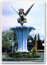 The northern
region of Buleleng stretches from east to west in a narrow
coastal strip backing onto foothills that reach up to the
central mountain ranges. Along the coastline rice fields reach
almost to the sea, and there are a series of lovely secluded
beaches, perfect for water sports and skin-diving, with
colorful underwater coral grottos. The northern
region of Buleleng stretches from east to west in a narrow
coastal strip backing onto foothills that reach up to the
central mountain ranges. Along the coastline rice fields reach
almost to the sea, and there are a series of lovely secluded
beaches, perfect for water sports and skin-diving, with
colorful underwater coral grottos.
The Kingdom of Buleleng rose to power
during the 17th century, under the leadership of
Gusti Pandji Sakti, who extended his realm of authority to the
neighboring kingdoms of Karangasem and Jembrana. An
association with Mengwi lasted till the end of the
18th century, when the two kingdoms separated again
and lost their powers to the warring princes of
Karangasem.
Dutch control began in 1848, ending the
feudal rule of the Rajas. The women of Buleleng were the first
to adopt the Kebaya Malay blouse which was enforced by Dutch
rule "to protect the morals of the Dutch soldiers". Singaraja
was chosen by the Dutch because of its excellent harbor as
their capital.
The Banjar system of sub-village
communities in North Bali is not as institutionalizes as it is
in South Bali. The way of life centres more around the
individual family with the accompanying effect that the caste
system is not as rigid as in the south.
 Singaraja’s
long history as the major port in Bali has resulted in a mixed
population of Muslims and Chinese as well as the indigenous
Balinese. The city was always a trading centre for the Bugis
sea traders, former pirates who operated throughout the
archipelago from their home ports in Sulawesi. Chinese
influence from the merchants who have made Singaraja their
home for thousands of years is also quite apparent, the long
association with the Dutch has resulted in many imposing
residences of European design. Hotel Singaraja was the former
seat of the Dutch Governor. Singaraja’s
long history as the major port in Bali has resulted in a mixed
population of Muslims and Chinese as well as the indigenous
Balinese. The city was always a trading centre for the Bugis
sea traders, former pirates who operated throughout the
archipelago from their home ports in Sulawesi. Chinese
influence from the merchants who have made Singaraja their
home for thousands of years is also quite apparent, the long
association with the Dutch has resulted in many imposing
residences of European design. Hotel Singaraja was the former
seat of the Dutch Governor.
The Gedung Kertya, the most extensive
library of ancient lontars, palm-leaf books containing a
wealth of manuscripts on history, literature, medicine and
mythology, just near the hotel Singaraja, was first
established by the Dutch.
Exploring the
North Coast
There are several ways of approaching
Singaraja from the south. The central mountain road, which is
linked by regular public transport service, passes through a
cross-section of the island via the crater lakes of Bedugul,
taking in grand scenic panoramas of the entire
island.
Another road takes a more westerly route
from Denpasar, passing through the hilltop village of Pupuan.
Other roads approach the region from the transit port to Java,
Gilimanuk, on the island’s western extremity, from Amlapura in
east Bali via a fairly rugged coastal road that passes through
Kintamani.
The border between Tabanan and Buleleng
regencies on the central mountain route to Singaraja falls in
the midst of Bedugul resort, just past the sparkling Lake
Beratan, at the entrance to the village of Pancasari. Here the
18-hole championship golf course of Bali Handara, mentioned
earlier, lies at the end of a small side-road that winds
through spectacular 100 hectare property.
Past the village of Pancasari the road
once more winds up to the lip of the crater. From Asah Gobleg
the entire lowlands of north Bali stretch out before the eye
to the fringe of coast in the distance. Another mountain route
can be reached via Tabanan, turning at Antosari and climbing
up into the hills where vanilla beans grow in every spare plot
of land, to the coffee plantations of Pupuan.
The road from Gilimanuk passes through the
West Bali National Park, which extends as far as Teluk Terima,
a sheltered bay where simple accommodation is available and
boats can be arranged to cross to Menjangan Island, part of
large underwater reserve that has some of the most beautiful
coral grottos to be seen in this part of the world.
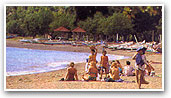 Just 14
kilometers before Singaraja, fronting the secluded beaches,
begins a stretch of small lodges offering simple
accommodation, some of which have restaurants and water sports
facilities. Lovina Beach resorts, as it is known, actually
covers and area of nearly eight kilometers of idyllic
coastline, including the beaches of Lovina, Kalibubuk, and
Tukad-Mungga. Just 14
kilometers before Singaraja, fronting the secluded beaches,
begins a stretch of small lodges offering simple
accommodation, some of which have restaurants and water sports
facilities. Lovina Beach resorts, as it is known, actually
covers and area of nearly eight kilometers of idyllic
coastline, including the beaches of Lovina, Kalibubuk, and
Tukad-Mungga.
The approach to Singaraja from the eats is
equally as scenic. The eastern lowlands and foothills are full
of orchards: mandarins mangoes, oranges, grapes, and durian
grow here seasonally in great quantities From Amlapura the
coast passes through a rocky, arid area emerging at the
oasis-like village of Air Saneh, with its fresh, spring-fed
pool by the sea and quiet cottages, a popular weekend resort
for the townspeople of Singaraja. The route through Kintamani
winds down the ranges in a series of hairpin bends, passing
through the town of Jagaraga.
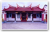
In Tejakula, 25 kilometers before
Singaraja, there stands an ancient temple, Pura Ponjok Batu,
which is surrounded by fresh water springs. Another
spectacular temple not to be missed is in the village of
Kubutan. Pura Meduwe Karang, devoted to "Ibu Pertiwi" (mother
earth) is full of detailed sculptures. Just two kilometers
further down the road, near the village of Sangsit, the
15th century Pura Beji, a "subak" rice field
temple, features gates and walls redolent with highly detailed
carvings.
|